Image courtesy of Nik Ramzi Nik Hassan/ Unsplash
If you’ve spent any time working with soil, you may have an intuitive sense of what differentiates “good” soil from “bad”—Good soil is dark and fragrant, perhaps, and bad soil is pale, compacted, rocky or crumbly. If you start to pay attention to the soil, you also know that it can vary widely across small areas. The soil at the top of a sandy hill is drastically different from a clay-rich point lower in the same field. What is harder to see is the gradient of changes in soil conditions between those two extremes. How can we dig into these soil characteristics, as they relate to captured carbon or crop production across space and time? What about a user-friendly tool that can account for geographic diversity and inform you where you should collect soil samples? Enter SoilStack, Our-Sci’s open source stratification and soil sampling app.
One of Our-Sci’s core missions is to create community-driven, affordable, easy-to-use tools to capture information about soil and environmental health. SoilStack is an app designed to support smart soil sampling, capturing patterns of spatial variability and guiding users through field collection in a transparent, replicable, and user-friendly way. Rather than taking a high density of samples in a uniform grid and hoping that the variability of a site will be visible after the fact, SoilStack users will be able to conduct in-field assessments and optimize sampling within their site, resulting in high-quality sample plans without the prohibitive labor requirements and expense of traditional sampling.
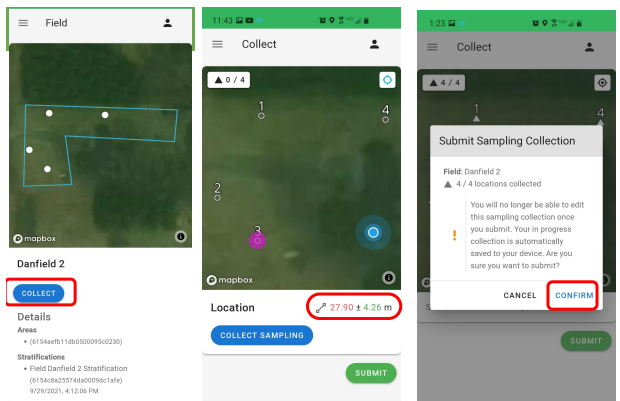
Fig. 1 – Screenshots of a demonstration test field in SoilStack
The key power of SoilStack is in its ability to crunch large amounts of relevant information to create a sampling plan that captures the full complexity of a site in the fewest possible points. SoilStack pulls data from a range of sources to build a robust picture of the diversity within a given field.
There are many publicly available sources of applicable information, from plant growth indices to topographic maps to soil-specific information that can help you understand your fields. However, accessing and synthesizing those data layers is a challenging prospect. SoilStack fetches and processes those layers for you, stratifies them into unique zones, and returns recommendations for how many soil samples are needed based on levels of variability and user preference–delivering a functional map that tells you where and how much to sample.
Of course, knowing where you should sample is only half the battle. You also need to be able to navigate efficiently. In the field, SoilStack provides a directed path to guide soil samplers to their sampling points without wasted effort. At each point, the app captures key metadata such as GPS location and timestamp, and users will have the ability to enter additional relevant information.
Fig. 2 – Visualization of the current user process, and additional functionality we are currently developing.
Organizations looking to establish functional carbon and ecosystem services markets are interested in quantifying soil carbon stocks with a high degree of certainty. Rather than depending solely on models for their assessments, organizations such as ESMC want the dependability of a system based on direct in-field measurements. However, typical methodologies for field sampling are far too expensive and time-consuming for a typical farmer to deploy on their own. Not only does a stratified sampling method like SoilStack lower cost, but for some carbon market options such as the Australian Soil Carbon Standard or the FAO’s GSOC MRV Protocol, a degree of stratification is actually required. In addition, stratification could reduce costs even for groups that have existing sampling processes– so regardless of regulation, it’s a win.
To date, Our-Sci has developed SoilStack in conjunction with the ESMC data portal, and has successfully stratified and collected data from hundreds of their fields. The next step is to take this information and expand it for a broader set of users. This summer, Our-Sci created a collaborative plan with OpenTeam hub farms, testing calibrations and integrations to make SoilStack work for their growers and research partners.
One promising area of expansion is the modularization of SurveyStack features, which would allow for the inclusion of field measurements, soil health surveys, and other flexible tools and protocols. Using SurveyStack’s collect features, users would be able to create their own surveys, then complete them in the SoilStack app. This information will be linked to their metadata using the SurveyStack database, allowing for integration with other tools in OpenTEAM and beyond.
These tools include the Our-Sci Reflectometer, which hub farms are using to test real-time mapping and field measurement of soil organic carbon. We’re also developing a decision support tool at the stratification stage that would allow users to adjust parameters such as sampling density and cost, and then re-stratify their map to better meet the needs of their research. Eventually, users could use SurveyStack’s API to pull metadata directly into ecosystem service marketplaces, merge their data with readings from other tools, and export it for outside auditing or analysis.
This is our goal: an open-source, all-inclusive, flexible tool to make better decisions about soil sampling, while maintaining clear permissioning and the ability to adapt to future needs. As we work to make SoilStack both powerful and easy to use, we need your feedback! Are you part of a community that needs soil sampling support? Are you interested in testing the next generation of SoilStack? Contact our team at info@our-sci.net, and let’s make a plan to turn your dirt into soil.